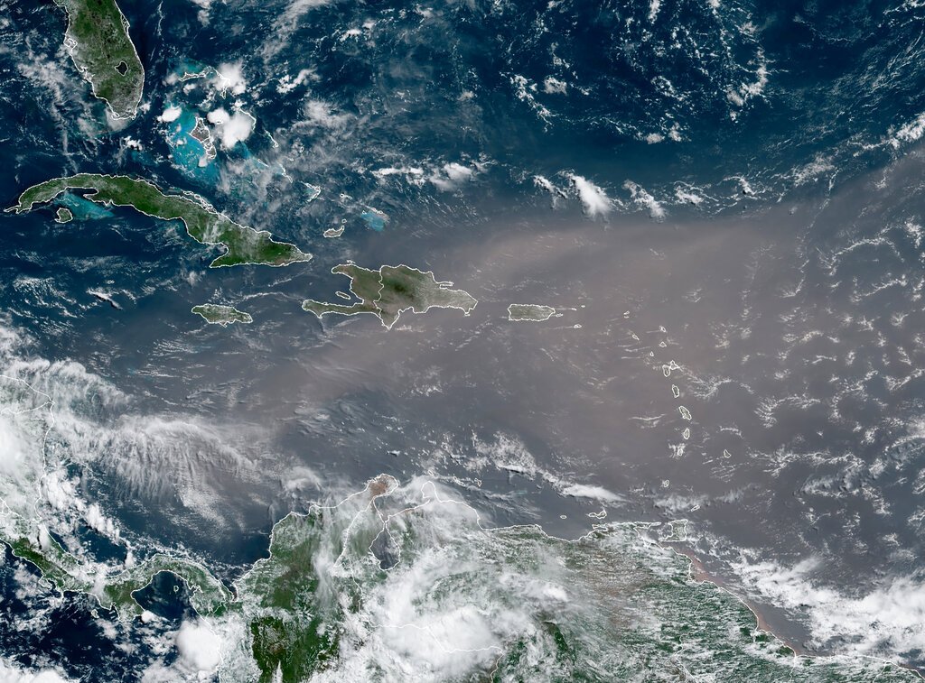
An enormous plume of Saharan dust, spanning an area comparable to the continental United States, is currently influencing weather patterns across the southern United States, with effects that extend far beyond the region's borders. Meteorologists say the dust layer is suppressing thunderstorm and hurricane development, contributing to a prolonged heat wave, and painting the skies with vivid sunsets.
Jason Dunion, a University of Miami meteorologist who collaborates with NOAA's Hurricane Research Division, described the Saharan Air Layer as a “layer cake” of warm, dry, dusty air that begins roughly a mile above the Earth's surface and extends about 2.5 miles thick. “They roll off of Africa in the summertime every three to five days, and they're huge. They're about the size of the lower 48 states as they cross the Atlantic,” Dunion said.

The dust season typically peaks from mid-June to mid-August, and this year's plume has been particularly robust. Rebecca Barry, a meteorologist at Nexstar's WFLA in Tampa, noted the unusual strength of the current plume. “Look at this late-season plume. That is healthy,” she said. “That looks like a late-May or June plume of Saharan dust. It is pretty rare that this late in the season we have such a healthy plume of Saharan dust breaking off from the coastline of Africa and moving across the Atlantic.”
The primary effect of the Saharan Air Layer is its ability to “cap” the atmosphere, preventing the vertical development of clouds and thunderstorms. “It really helps to cap the atmosphere,” Dunion explained. “It makes it very hard for thunderstorms and clouds to break that really warm layer.” This suppression is a key reason the Atlantic hurricane season has started quietly, as dust plumes inhibit the formation of tropical depressions that could otherwise strengthen into named storms.
The lack of afternoon thunderstorms, which typically provide relief from summer heat, has exacerbated temperatures across the South. “We don't really get those cool afternoon thunderstorms that we usually get when we've got these dust outbreaks overhead. So they tend to be in the hottest days of the year, and we've had heat indexes getting up to 110,” Dunion said.
The dust's reach extends beyond the Gulf Coast. Freddy Vela, a meteorologist at Nexstar's KXAN in Austin, showed back-to-back waves of Saharan dust sweeping across Texas and as far west as Arizona. This pattern has kept temperatures elevated and limited precipitation in those areas.
One of the more pleasant side effects of the dust is the enhanced beauty of sunrises and sunsets. As the dust particles scatter sunlight, they produce an orange glow at dawn and dusk. “To me, it's amazing,” Dunion said. “It's traveled 3,000, 4,000 miles across the Atlantic but you can still see it.”
While the dust is currently suppressing storms, it also carries implications for air quality and respiratory health, though those effects were not detailed in the original report. For now, residents across the southern U.S. can expect continued hot, dry conditions and spectacular evening skies.